Dashboard-mounted GPS units are almost as common as iPods, and now this network of location sensors is crowd-sourcing its resources by feeding into smart transportation systems that improve traffic management and planning.
"Our services are not just for consumers anymore," said Nick Cohn, business development manager at TomTom. "The individual drivers in their cars have more current information about the condition of the road than the government authorities have, but [we] can help close that gap."
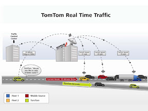
TomTom amalgamates real-time traffic information from many sources--including its dashboard-mounted GPS receivers, its iPhone app users and TomTom fleet users--and then gives time-saving rerouting suggestions to travelers with specific times-to-destination instead of miles or kilometers. (Source: TomTom)
As one of a handful of dedicated GPS navigation unit providers, TomTom has also become one of the favorite iPhone applications. Its hardware is also built into the dashboards of Renault, Alfa Romeo, Fiat, Toyota, Mazda and Subaru. Additionally, its traffic data is displayed by the navigation units built by GM, Audi, Mercedes Benz, Ford, BMW and VW. TomTom also has deals to provide GPS tracking and reporting units for fleets worldwide so that management always knows where its cargo trucks are located. All these navigation units are communicating with TomTom's real-time servers, where algorithms run to analyze the data from both consumer and industrial users and provide rerouting suggestions, as appropriate, to drivers.
At the ITS World Congress (held last week in Orlando, Fla.), TomTom described its vision of the future where crowd-sourced information flowing through its servers helps governments around the globe to manage traffic and simplify urban planning as well as help industry fleets and individual drivers find their way about, not by the shortest route in miles, but by the quickest time on the clock.
"In The Netherlands, for instance, they are putting a freeway underground in a project that will take seven years," said Cohn. "To reroute commuters, they need to give them up-to-date information, but they have no hardware on the ground but their smart signs; we provide all the information to the signs."
TomTom is currently offering real-time and historical traffic information to industrial and government users in 18 countries globally, including Australia, Austria, Belgium, Canada, France, Germany, Ireland, Italy, Luxembourg, the Netherlands, New Zealand, Poland, Portugal, South Africa, Spain, Switzerland, the United Kingdom and the United States. TomTom also promises to continue rolling out real-time traffic services in the remaining countries it serves through 2012.
Further Reading
